You probably grew up looking at a classroom map that showed seven continents. North America, South America, Europe, Asia, Africa, Antarctica, and Australia. It felt settled. Simple. But nature doesn’t really care about our maps, and honestly, the zealandia new zealand continent proves that we’ve been missing a massive piece of the puzzle for centuries. We are talking about a landmass roughly the size of India—nearly five million square kilometers—that just happened to be hiding under the Pacific Ocean.
It's weird to think about.
How do you "miss" a continent? Well, when 94% of it is underwater, it’s pretty easy to overlook. For a long time, scientists just assumed the islands of New Zealand and New Caledonia were isolated volcanic outposts. They weren't. They are the highest mountain peaks of a sunken world.
The 2017 Breakthrough That Changed Everything
In 2017, a team of eleven geologists led by Nick Mortimer published a paper that basically shook the scientific world. They didn’t just find a new island; they argued that Zealandia met every single physical requirement to be called a continent. It has high elevation compared to the surrounding ocean floor. It has a specific variety of rocks like igneous, metamorphic, and sedimentary. It has a thick crust. Most importantly, it has well-defined limits.
It isn't just a piece of seafloor.
The zealandia new zealand continent is made of continental crust, which is much thicker and less dense than the oceanic crust surrounding it. Imagine a giant piece of cork floating in a tub of water, while everything else is heavy lead. That’s Zealandia. It’s floating, just not high enough to clear the waves.
Why Did It Sink?
About 80 million years ago, Zealandia was part of the supercontinent Gondwana. You've probably heard of it—the massive landmass that included Antarctica and Australia. But then things got messy. As the tectonic plates started pulling apart, Zealandia began to stretch. Think of it like pulling a piece of pizza dough. The more you stretch it, the thinner it gets in the middle.
Eventually, the crust got so thin that it lost its buoyancy.
By the time it fully broke away from Australia and Antarctica roughly 60 million years ago, it was already heading for the deep. It didn't "sink" in a sudden, Atlantis-style catastrophe. It was a slow, agonizing descent over millions of years. Today, only about 6% of it remains above sea level. This includes New Zealand’s North and South Islands, Stewart Island, and New Caledonia to the north.
The Rock That Proves the Point
Geologists like Maria Seton have spent years pulling up rocks from the dark depths of the Tasman Sea. What they found was fascinating. They didn't find the typical basalt you see on the ocean floor. Instead, they found granite and sandstone.
These are continental rocks.
In some spots, the crust of the zealandia new zealand continent is between 10 and 30 kilometers thick. Compare that to the surrounding oceanic crust, which is usually only about 7 kilometers thick. That thickness is the "smoking gun" for geologists. It tells us that this landmass has a history far more complex than a simple underwater mountain range. It was once a dry, thriving landscape where dinosaurs likely roamed.
Actually, we know they did. Fossil evidence found in New Zealand, like the sauropod fossils discovered by Joan Wiffen, proves that when Zealandia was part of Gondwana, it was a lush forest teeming with life.
Why This Matters for You
You might think this is just a bunch of scientists arguing over definitions. It isn't. The recognition of Zealandia has massive implications for international law and resources. Under the United Nations Convention on the Law of the Sea, countries can claim "continental shelf" areas for mineral and resource rights.
If New Zealand is part of a continent, its maritime boundaries change.
There's also the biological aspect. Zealandia’s isolation is why New Zealand has such "wonky" wildlife. Because the continent broke away and then partially submerged, the animals that survived were the ones that could fly or handle the changing terrain. It explains why New Zealand has no native land mammals (except for a couple of bats). It’s a biological time capsule.
The Problem With "Seven" Continents
We love nice, round numbers. Seven continents feels right. But if we use the scientific definition—large, elevated areas of thick crust separated by oceanic crust—then Zealandia has to be on the list. Some geologists even argue that Europe and Asia should be one continent (Eurasia). If we go by the "Zealandia rules," the count changes.
It forces us to admit that our maps are based on where the water is, not where the land ends.
Mapping the Invisible
Mapping an underwater continent is an absolute nightmare. You can't just take a satellite photo. Scientists use bathymetry—basically using sonar to bounce sound waves off the bottom of the ocean to see the shape of the terrain.
More recently, gravity mapping has been the game-changer.
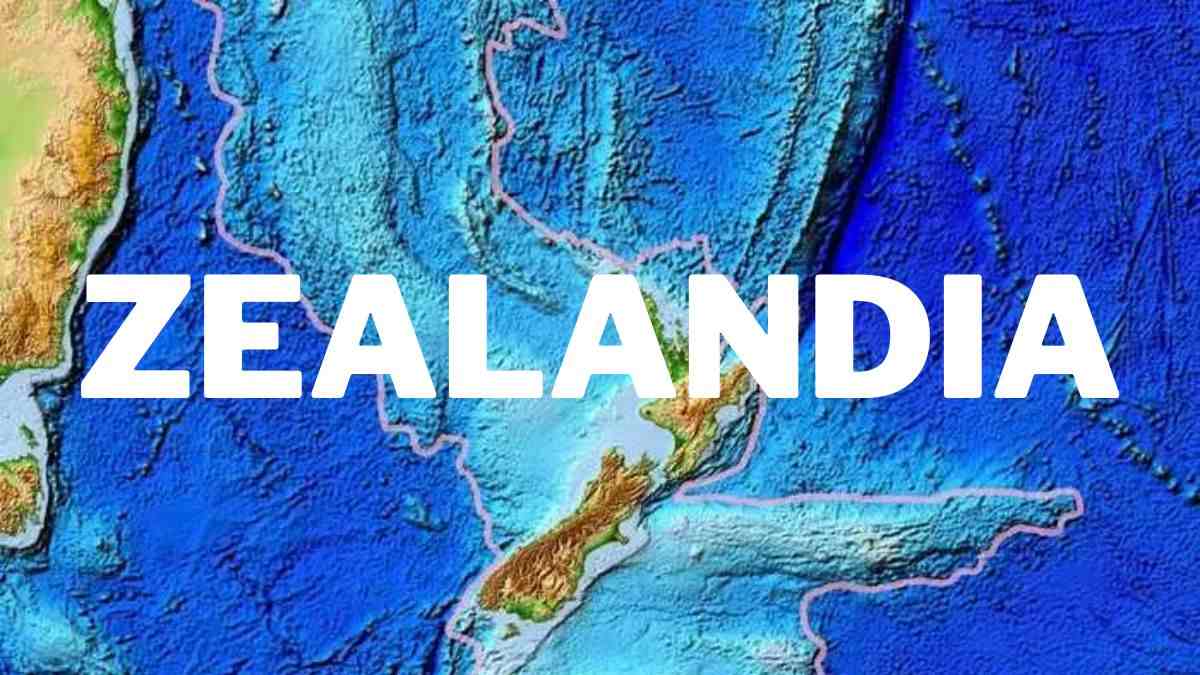
Satellites can detect tiny variations in Earth’s gravity caused by the mass of the rocks below. Because continental crust is different from oceanic crust, it shows up on gravity maps as a distinct "lump." This is how we finally saw the clear borders of the zealandia new zealand continent. It looks like a long, narrow strip stretching from south of New Zealand all the way up past New Caledonia.
Misconceptions About the "Eighth" Continent
A lot of people hear "sunken continent" and think of Atlantis. Let’s be clear: there was never a high-tech civilization living on Zealandia that vanished into the sea. By the time humans arrived in New Zealand—the Māori around 1300 AD—the continent had been underwater for tens of millions of years.
It’s also not "growing." If anything, tectonic activity is still twisting and pulling it. The boundary between the Indo-Australian and Pacific plates runs right through the middle of the South Island. This is why New Zealand has so many earthquakes and volcanoes. The continent is being squeezed and shifted every single day.
What to Do With This Information
If you're a traveler or a student of geography, the existence of the zealandia new zealand continent changes how you look at the South Pacific. It isn't just a bunch of islands in a big blue void. It’s a vast, drowned wilderness.
Here is how you can actually "experience" Zealandia:
- Visit Zealandia Te Māra a Tāne: This is a famous eco-sanctuary in Wellington. While it's a fenced valley for birds, it’s named after the continent and focuses on preserving the flora and fauna that would have dominated the landmass millions of years ago.
- Explore the Southern Alps: When you stand on top of a mountain in the South Island, you are standing on the highest "wrinkle" of the Zealandia crust. These mountains are being pushed up even as the rest of the continent stays submerged.
- Go to New Caledonia: Most people don't realize that New Caledonia is the northern tip of Zealandia. The geology there is wildly different from volcanic islands like Fiji or Tahiti. It’s old, continental land.
- Check the GNS Science Maps: The New Zealand geological agency (GNS) has released incredibly detailed maps of the continent. They are public and show the sheer scale of the ridges and plateaus that sit beneath the waves.
The story of Zealandia is a reminder that the Earth still has secrets. We think we’ve mapped everything because we have GPS and Google Earth, but we’ve mostly just mapped the parts where we don't get our feet wet.
The zealandia new zealand continent is a massive, silent witness to the earth's shifting plates. It tells a story of stretching, sinking, and survival. Next time you look at a globe, don't just see the blue as "empty space." See it as a cover for the geography we’re still trying to understand.
To stay truly informed on this evolving topic, follow the research coming out of Deep South National Science Challenge or the IODP (International Ocean Discovery Program). They are the ones currently drilling into the seafloor to bring up more of Zealandia's history. Read the 2017 paper "Zealandia: Earth’s Hidden Continent" in GSA Today for the full technical breakdown of why this landmass earned its title.