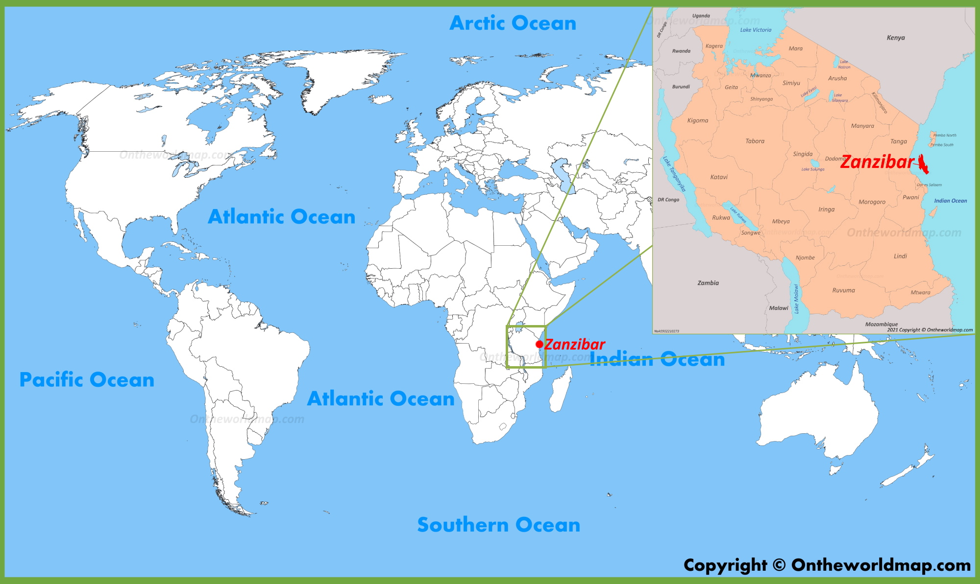
Where is Zanzibar? Most people just point vaguely at the "right side of Africa" and call it a day. Honestly, if you look at a Zanzibar location on map search result, you’ll see a tiny speck in the Indian Ocean that looks like it’s barely hanging onto the continent. It’s way more than just a beach destination, though. It’s a literal archipelago. That’s the first thing people miss. Zanzibar isn't just one island; it’s a collection, with the two biggest being Unguja and Pemba.
Unguja is what everyone actually means when they say "Zanzibar."
If you’re staring at a globe, find the equator. Slide your finger down about six degrees south. Now look at the coast of Tanzania. There it is. It’s roughly 25 to 50 kilometers (15–30 miles) off the mainland. Close enough that you can see the lights of Dar es Salaam on a clear night if you’re on the southern tip, but far enough that it feels like a completely different planet. The geography here is weirdly specific. The islands sit on the edge of the continental shelf, which means the water between the islands and the mainland is relatively shallow, but once you head east towards the open ocean, the depth drops off into the abyss fast.
Zooming in on the Zanzibar Location on Map
When you zoom in, the shape of Unguja is unmistakable. It’s long and thin, stretching about 85 kilometers from north to south. It’s got this jagged, coral-rag coastline that makes for some of the most insane turquoise water you'll ever see. But here’s the thing: the map doesn't show you the tides. Because of where Zanzibar is positioned—tucked into the bight of the East African coast—it experiences some of the most dramatic tidal shifts in the world.
At low tide in places like Michamvi or Paje, the ocean basically disappears. It retreats for miles. You can walk out to the reef edge, past seaweed farms and tide pools. Then, six hours later, the Indian Ocean comes roaring back, swallowing the beach whole.
Why the Latitude Matters for Your Tan
Being at 6°S latitude isn't just a coordinate for pilots. It dictates the entire vibe of the island. You’re in the tropical belt. This means the sun doesn't mess around. It’s direct. It’s intense. Because it’s so close to the equator, the days and nights are almost exactly the same length all year round. Twelve hours of light, twelve hours of dark. No long summer evenings here; the sun drops like a stone around 6:30 PM, every single day.
The Pemba Paradox
Most travelers never look north on the map. If they did, they’d see Pemba Island. It’s the "Green Island." While Unguja is relatively flat—its highest point is just 119 meters above sea level at the Koani hills—Pemba is hilly and fertile. The soil there is different. It’s deep and dark. This is where most of the world’s cloves come from. If you're looking at a Zanzibar location on map and you ignore that northern neighbor, you’re missing half the story. Pemba is separated from the mainland by the Pemba Channel, which plunges to depths of over 800 meters. This deep water is why Pemba is a mecca for big-game fishing and divers looking for vertical wall drops that feel like falling into space.
Stone Town: The Map’s Heartbeat
Look at the western "bulge" of Unguja. That’s where Zanzibar City sits. The historical core, Stone Town, is a labyrinth. Maps are almost useless inside those narrow limestone alleys. The architecture tells the story of the location: it’s a blend of African, Persian, Indian, and European influences. For centuries, the "Monsoon Trade" relied on the geographical position of Zanzibar.
Sailors from the Arabian Peninsula would use the Kaskazi (north-easterly) winds to sail down to Zanzibar between December and March. Then, they’d wait. They’d trade their carpets and dates for cloves and ivory. Once the Kusi (south-westerly) winds kicked in between May and October, they’d hitch a ride back north. Zanzibar wasn't just a stop; it was the waiting room of the Indian Ocean.
The Myth of the "Island"
Technically, "Zanzibar" is a semi-autonomous region of Tanzania. It’s not its own country, though it has its own president and parliament. This political geography is just as important as the physical stuff. When you look at a map of Tanzania, you see the massive expanse of the Serengeti and Kilimanjaro. Zanzibar looks like an afterthought. But historically, the Sultan of Zanzibar once controlled a massive strip of the mainland coast. The map used to look very different.
Navigating the Reefs
The eastern coast of Zanzibar is protected by a massive barrier reef. On a satellite map, this looks like a thin, white line of surf breaking a mile or two out from the shore. Inside that line, the water is a calm, neon-blue lagoon. Outside, it’s the wild Indian Ocean. This reef is the reason why the east coast has those postcard-perfect white sand beaches like Nungwi and Kendwa.
However, the "best" location on the map is subjective:
- North (Nungwi/Kendwa): The most "swimmable" beaches because the tide doesn't retreat as far.
- East (Paje/Jambiani): The kite-surfing capital. Windy, shallow, and wide.
- West: Best for sunsets and proximity to the airport.
- South (Kizimkazi): Rugged, rocky, and home to resident dolphin pods.
How to Actually Get There
Most people fly into Abeid Amani Karume International Airport (ZNZ). It’s located just south of Stone Town. Alternatively, the ferry from Dar es Salaam is a rite of passage. It takes about two hours. You cross the Zanzibar Channel, which can be surprisingly choppy. If you’re prone to sea sickness, the "location on map" suddenly feels a lot further away than 30 miles.
The logistics of the island are shaped by its isolation. Everything—from your bottled water to the fuel for the "dala-dala" (local minibuses)—mostly comes by ship. This makes Zanzibar more expensive than the mainland, but that’s the "island tax" you pay for paradise.
Actionable Insights for Your Visit
Don't just stare at the map; use it to plan. If you want the classic turquoise water experience without the tide disappearing on you, stay in the Northern tip (Nungwi). The geography there allows for swimming all day long.
If you're a history nerd, spend at least two nights in Stone Town. It’s the only way to feel the pulse of the old trade routes.
For the adventurers, look at Pemba. It’s harder to get to—usually requiring a small puddle-jumper flight—but it’s what Zanzibar felt like thirty years ago.
Lastly, check the moon phases before you book. Because the Zanzibar location on map is so sensitive to the Indian Ocean's tides, a full moon means massive tidal swings. This is great for reef walking but might frustrate you if you just want to lounge in the water at 2:00 PM.
Pack high-SPF sunscreen. Seriously. Being six degrees from the equator means you will burn in twenty minutes, even if it's cloudy. The geography doesn't lie; the sun is closer here. Understand the layout, respect the tides, and you'll see why this tiny spot on the map has been the center of the world for so many explorers.
Next Steps for Your Trip Planning:
- Check the Tide Charts: Download a tide app specifically for the Zanzibar Channel to see how the ocean will behave during your specific travel dates.
- Verify Visa Requirements: Most visitors need a Tanzanian eVisa, which covers the islands as well.
- Pin Your Points of Interest: Mark the "Safari Blue" departure point in Fumba and the Jozani Chwaka Bay National Park (the only place to see the endemic Red Colobus monkeys) on your offline maps before you arrive.