If you pull up a map of Africa and let your eyes drift toward the center-south, you’ll find a country shaped roughly like a butterfly—or a twisted peanut, depending on how much coffee you’ve had. That’s Zambia. Honestly, for a lot of people, it’s just that "big country above South Africa," but finding Zambia on a map of Africa is actually the key to understanding how the entire southern half of the continent breathes.
It doesn’t have a coastline. No white sandy beaches on the Atlantic or the Indian Ocean. But don't call it "landlocked." The locals and geographers who know their stuff prefer the term landlinked. When you see where it sits, you realize it’s basically the transit lounge of Southern Africa. It touches eight different countries. Eight! That’s a lot of neighbors to keep happy.
Where Exactly Is It?
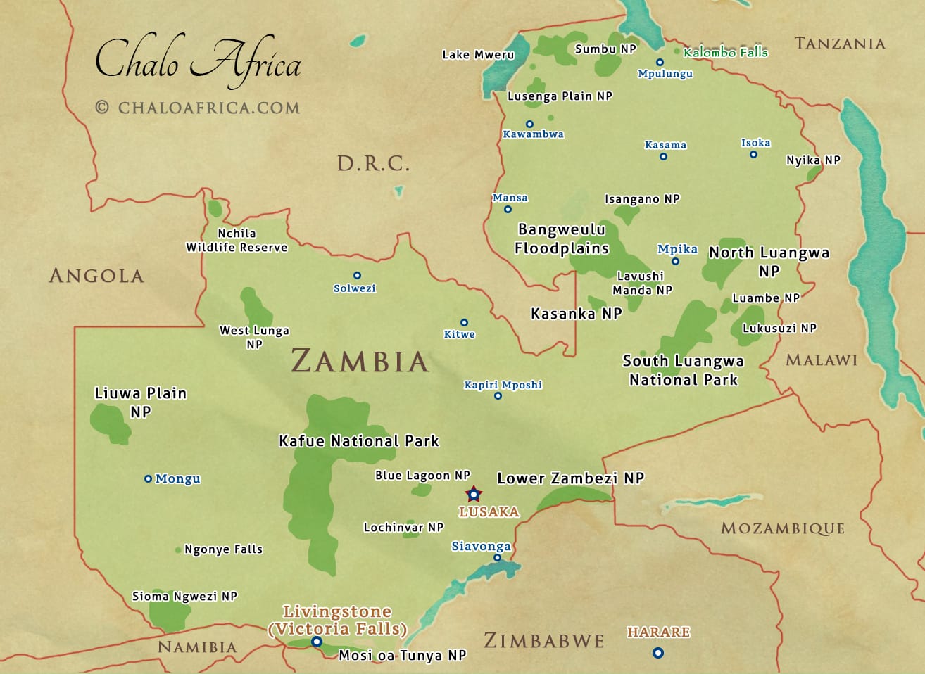
To find it quickly, look for the "Congo Pedicle"—that weird piece of the Democratic Republic of the Congo (DRC) that stabs right into Zambia’s side like a finger. Zambia wraps around it.
To the north, you’ve got the DRC and Tanzania. To the east, there's Malawi. Mozambique sits to the southeast. Zimbabwe, Botswana, and Namibia (specifically the skinny Caprivi Strip) line the southern border. Finally, Angola hems it in on the west.
It’s a massive piece of land. We’re talking about 752,618 square kilometers. To put that in perspective, it’s bigger than France but slightly smaller than Turkey. If you’re from the States, think of it as roughly the size of Texas. It’s not small, yet it often gets visually swallowed by its giant neighbor to the north or the famous safari draws to its south.
The Watery Borders You Can See From Space
Even though there's no ocean, Zambia is defined by water. The country literally takes its name from the Zambezi River. If you're looking at Zambia on a map of Africa, the southern border is almost entirely defined by this massive river and the man-made Lake Kariba.
The Victoria Falls Marker
The most famous "X marks the spot" for Zambia is Victoria Falls (Mosi-oa-Tunya). It sits right on the border with Zimbabwe. If you find the zig-zagging line of the Zambezi River between the two countries, that’s where the "Smoke that Thunders" lives.
The Three Great Lakes
Zambia also hits the "big water" jackpot in the north. It touches the southern tip of Lake Tanganyika, which is the second deepest lake in the world. Then there's Lake Mweru on the border with the DRC, and the massive Bangweulu Swamps right in the middle of the northern plateau. It’s a weirdly soggy country for being in the middle of a plateau.
What the Terrain Actually Looks Like
Most of Zambia is a high plateau. Imagine a giant, flat table sitting between 3,000 and 5,000 feet above sea level. This is why the weather isn't as "melting-hot-tropical" as you'd expect for its latitude.
- The Copperbelt: Up near that "finger" of the DRC is the Copperbelt. It’s the industrial heart. On a political map, you’ll see a dense cluster of cities like Ndola and Kitwe here.
- The Luangwa Valley: Over on the eastern side, near Malawi, the land drops away into the Luangwa Valley. This is part of the Great Rift Valley system. It’s wild, remote, and where you go if you want to see a leopard eat an impala.
- The Kalahari Sands: In the far west, near Angola, the soil changes. It becomes sandy and dry—the very edges of the Kalahari basin.
Why the Location Matters for 2026
Zambia’s spot on the map makes it a geopolitical "middle child" that everyone needs to be friends with. Because it connects the mineral-rich DRC to the ports in Tanzania, Namibia, and South Africa, it’s a massive logistics hub.
When you look at the roads—like the Great North Road or the TAZARA railway—you see they all funnel through this one central block. If Zambia has a "bad day" and closes a border, half of Southern Africa’s trade basically grinds to a halt.
Practical Takeaways for Your Mental Map
If you're trying to memorize where it is or planning a trip, keep these three things in mind:
- The "Butterfly" Shape: It’s the most distinct shape in the region once you see it.
- The Central Hub: It’s the only country that bridges the gap between the "safari south" and the "jungle center" of Africa.
- The High Altitude: Remember it’s a plateau. On a physical map, it’ll be colored light brown or tan, not the deep green of the Congo basin or the yellow of the Namib desert.
Next Steps for Your Research
If you’re actually planning to visit or study the region further, look into the Kazungula Bridge. It’s a feat of engineering at the "quadripoint" where Zambia, Namibia, Botswana, and Zimbabwe almost meet at a single point in the river. It’s a literal crossroads that shows why being "landlinked" is Zambia’s biggest superpower.
Check out the updated 2026 transit maps if you're looking at trade routes; the Lobito Corridor expansion is currently shifting how goods move from Zambia’s mines to the Atlantic, which is changing the country’s economic map in real-time.