If you look at a zambia map in africa, the first thing you’ll probably notice is that it looks like a giant, slightly squashed butterfly. Or maybe a teapot? People argue about the shape, but honestly, it’s one of the most distinctive outlines on the entire continent. Situated right in the heart of South-Central Africa, Zambia is the ultimate "landlinked" country. I say landlinked instead of landlocked because, while it has zero coastline, it touches eight different countries. It’s basically the neighborhood crossroads.
Most people struggle to pin it down exactly. Is it East Africa? Southern Africa? Central? Depending on who you ask—or which trade block you're looking at—it’s all three. But if you're trying to find it on a map, just look for the big "S" curve of the Zambezi River forming the southern border.
The Butterfly and the Pedicle: Understanding the Shape
Look closely at the northern border. There’s a weird piece of the Democratic Republic of the Congo (DRC) that jabs right into Zambia’s "waist." This is called the Congo Pedicle. It’s a colonial-era hangover that almost cuts the country in half. Because of this "pedicle," traveling from the Copperbelt to the Luapula Province usually involves a long detour or crossing through a thin strip of DRC territory. It's one of those geographical quirks that looks like a minor drawing error on a map but creates massive logistical headaches for locals every single day.
Zambia covers about 752,618 square kilometers. To give you some perspective, that's roughly the size of France, the Netherlands, and Belgium all smooshed together. Or, for the Americans reading, it’s a bit larger than Texas.
The High Plateau Life
Most of the country isn't low-lying jungle. Far from it. Zambia sits on a massive, undulating plateau. You’re looking at elevations between 1,000 and 1,600 meters above sea level. This is why, despite being in the tropics, the weather is actually pretty chill for a good chunk of the year. If you’re in the capital, Lusaka, during June or July, you’re going to want a jacket. Seriously.
Why the Zambia Map in Africa is Defined by Water
Even though there's no ocean in sight, Zambia is defined by its rivers and lakes. The name itself comes from the Zambezi River. This mighty waterway doesn't just provide a name; it provides the country's most famous landmark: Victoria Falls (Mosi-oa-Tunya).
- The Zambezi: It starts in a tiny, unassuming spring in the Mwinilunga District (North-Western Province) and winds its way through Angola before coming back to form the border with Zimbabwe.
- The Kafue: This is the longest river entirely within Zambia. It’s the lifeblood of the country’s central agriculture and the namesake of the massive Kafue National Park.
- The Luangwa: Running through the east, this river has carved out one of the greatest wildlife sanctuaries on the planet.
Then you’ve got the lakes. In the north, you share the southern tip of Lake Tanganyika with Tanzania and the DRC. It’s the second deepest lake in the world. It feels like an ocean when you're standing on the shore at Mpulungu. Then there’s Lake Kariba in the south, which is a massive man-made reservoir that looks like a sea, complete with "Operation Noah" history where thousands of animals were rescued as the valley flooded in the 1950s.
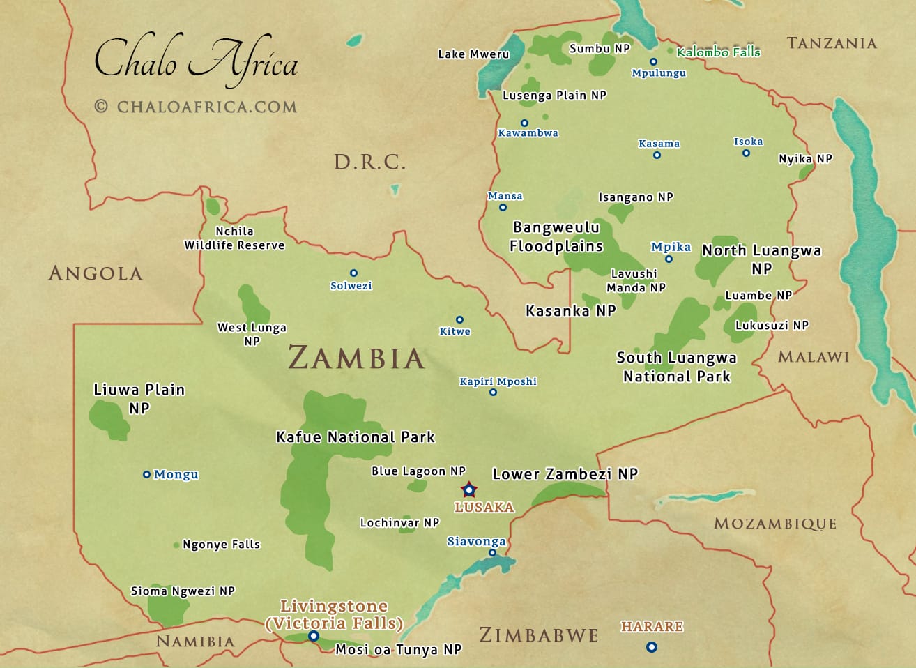
The 10 Provinces and Where to Go
If you're looking at a map of Zambia trying to plan a trip or just understand the layout, you've got to know the provinces. They aren't just administrative lines; they represent totally different vibes.
- Lusaka Province: This is the hub. Smallest province by area but densest by population. It’s where the money, the malls, and the traffic jams live.
- Copperbelt: North of Lusaka. As the name suggests, this is the industrial heartland. Cities like Kitwe and Ndola were built on mining.
- Southern Province: Home to Livingstone and the Falls. This is the tourism magnet.
- Western Province: This is where you find the Barotse Floodplain. It’s sandy, remote, and home to the Kuomboka ceremony, where the Lozi king moves from his summer home to his winter home on a giant black-and-white barge.
- Eastern Province: This is your gateway to South Luangwa. If you want to see leopards, you go here.
The rest—Northern, Muchinga, Luapula, North-Western, and Central—offer everything from the "African Stonehenge" (rock paintings) to some of the most remote waterfalls you’ll ever see. People often forget that Zambia has more waterfalls than almost anywhere else in the region, not just the "Big One" in Livingstone.
Border Neighbors and the Quadripoint Myth
One of the coolest things about the zambia map in africa is the spot where Zambia, Namibia, Botswana, and Zimbabwe almost meet. For years, people called it the "only quadripoint in the world."
Technically, it’s two tri-points separated by about 150 meters. But if you stand on a boat in the middle of the river near Kazungula, you are basically at the junction of four nations. It’s a geographic needle-thread that recently got a massive boost with the opening of the Kazungula Bridge, replacing a legendary (and slightly terrifying) ferry system that used to be the only way across.
Why Location Matters for 2026 and Beyond
Zambia’s central location is becoming its biggest economic asset. Being "landlinked" means it is the natural transit point for goods coming from South African ports heading to the DRC or Tanzania. If you’re looking at a regional map, you see the "Beira Corridor" and the "Lobito Corridor" all intersecting here.
Actionable Insights for Using a Zambia Map
If you are planning to navigate or study the region, keep these practical tips in mind:
- Don't trust travel times based on distance. 500 kilometers on a map might look like a 5-hour drive. In Zambia, if that road is undergoing "maintenance" or passes through the escarpment, it’s a 10-hour mission.
- Check the season. During the rainy season (November to April), many maps are basically useless for the "bush" areas. Roads in places like Lower Zambezi or Liuwa Plain simply disappear into the mud.
- Look for the Great North Road. This is the primary artery. It runs from the Zimbabwean border at Chirundu, through Lusaka, and all the way up to the Tanzanian border at Nakonde. It’s the spine of the country.
- Altitude affects your packing. Because of that plateau elevation I mentioned, always check the "meters above sea level" for your destination. It’s the difference between packing a swimsuit and a fleece.
Zambia is a place that rewards the curious. When you look at the map, don't just see the lines. See the massive drainage basins, the high-altitude mountains like the Mafinga Hills (the highest point at 2,339 meters), and the vast, open spaces that make it one of the last true wilderness frontiers left. It’s big, it’s friendly, and it’s right there in the middle of everything.