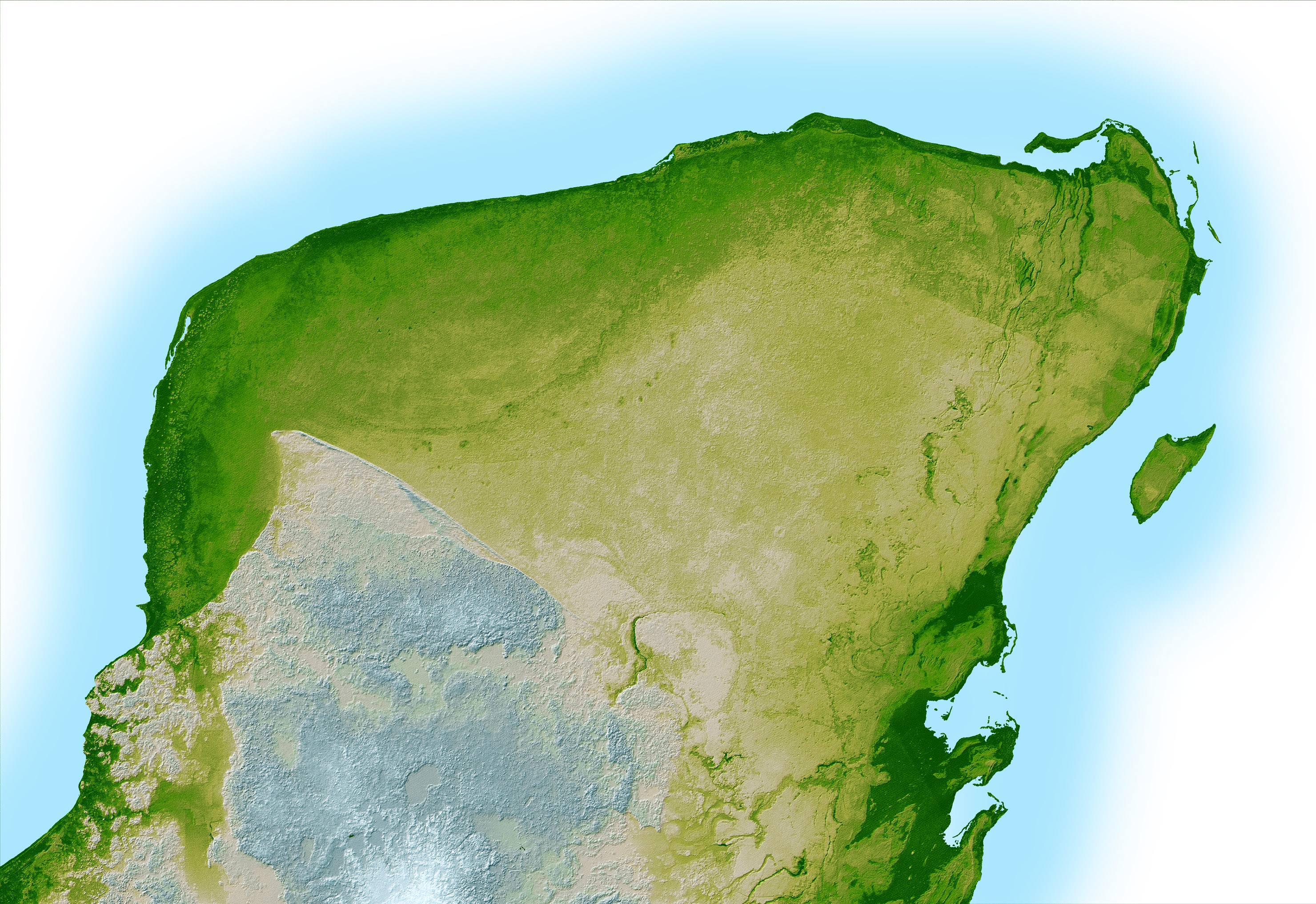
You’ve probably looked at a map of Mexico and seen that little thumb of land sticking out into the ocean on the bottom right. That’s the Yucatan Peninsula. Most people just think of it as "where Cancun is," but if you actually zoom in on a Yucatan Peninsula on Mexico map, you’ll realize it is a geological and cultural anomaly that doesn't really follow the rules of the rest of the country.
It’s flat. Like, incredibly flat. While the rest of Mexico is famous for the towering Sierra Madre mountains and rugged volcanic peaks, the Yucatan is basically one giant slab of limestone. Honestly, it’s more like a massive sponge than a piece of solid earth.
Where Exactly is the Yucatan Peninsula on a Mexico Map?
If you’re trying to find it, look at the southeastern corner. It’s the hook that separates the Gulf of Mexico from the Caribbean Sea. Most folks don't realize that the peninsula isn't just one state. It’s actually split into three Mexican states: Yucatan (the state), Quintana Roo (the tourist powerhouse), and Campeche (the quiet, colonial cousin).
Technically, the "peninsula" keeps going south into Belize and the northern tip of Guatemala, but when people talk about it in a Mexican context, they’re usually focusing on those three big states.
- Quintana Roo: This is the eastern strip. It’s where you’ll find Cancun, Playa del Carmen, and Tulum. It’s the Caribbean side.
- Yucatan State: This is the top-middle part. It’s the heart of Maya culture, home to the capital city of Mérida and the world-famous Chichén Itzá.
- Campeche: This sits on the western side, facing the Gulf of Mexico. It’s famous for its walled city and being way less crowded than the others.
The geography here is weird. Because the ground is porous limestone, there are virtually no surface rivers in the northern half of the peninsula. None. If you look at a detailed Yucatan Peninsula on Mexico map, you won't see blue lines snaking across the land like you do in the US or Europe. Instead, all the water is underground in a massive network of caves and sinkholes called cenotes.
The Asteroid That Changed the Map
There is a huge circular feature on the map that you can't even see from the ground. It's the Chicxulub crater. About 66 million years ago, a massive asteroid slammed into the northern coast of the peninsula, near the town of Chicxulub.
You know, the one that wiped out the dinosaurs.
That impact shattered the limestone and created a "Ring of Cenotes." If you look at a specialized geological map, you can actually see a perfect semi-circle of these sinkholes. They follow the edge of the buried crater. It’s one of the few places on Earth where a prehistoric catastrophe literally dictated where modern people get their drinking water today.
Why the Location Matters for Your Trip
The climate changes pretty drastically depending on where you are on that map. The northwest corner near Mérida is actually quite dry, almost like a scrubby desert. But as you move south toward the border with Guatemala, it turns into thick, humid rainforest.
The Caribbean coast (the east) gets the brunt of the Atlantic hurricane season. Since the land is so flat, there are no mountains to "break" the wind of a storm coming off the ocean. This is why towns like Mahahual or Tulum are so vulnerable; the geography offers zero protection.
On the flip side, the west coast (Campeche) faces the Gulf. The water there isn't that bright "electric blue" you see in Instagram photos of Cancun. It’s shallower, calmer, and a bit more green. It’s a completely different vibe.
Real Talk: Navigating the Map
Most travelers make the mistake of thinking they can "do" the Yucatan in a few days. Look at the scale. Driving from Cancun to Mérida takes about four hours on a straight, somewhat boring toll road. If you want to go all the way down to the ruins of Calakmul near the Guatemala border, you’re looking at a serious expedition.
The Hidden Cities You Missed
Everyone knows the big spots. Chichén Itzá is the heavy hitter. Tulum is the trendy one. But look closer at the Yucatan Peninsula on Mexico map for these less-obvious gems:
- Valladolid: It sits almost exactly in the middle of the northern part. It’s a "Pueblo Mágico" and serves as the perfect base camp.
- Izamal: Known as the "Yellow City" because... well, every building in the center is painted bright yellow. It’s built right on top of ancient Maya pyramids.
- Bacalar: Way down south near the Belize border. It’s called the "Lagoon of Seven Colors." It looks like the ocean, but it's a massive freshwater lake.
The Maya didn't pick these locations by accident. They built their cities where the water was. In a land with no rivers, a cenote was life. When you look at the map of ruins, they almost always overlap with the map of underground water sources.
Actionable Steps for Your Next Look at the Map
If you're planning a trip or just researching the area, don't just look at a generic Google Map.
- Check the Elevation: Notice the lack of contour lines. This means you can bike for miles without hitting a hill, but it also means the heat settles in and stays there. There's no "mountain air" to cool you down.
- Locate the "Puuc" Region: This is the only place with hills (small ones). It’s south of Mérida and has some of the best architecture at sites like Uxmal.
- Look for the Tren Maya Route: This is the new controversial train line. Understanding its path on the map will help you see which "hidden" areas are about to become much more crowded.
The Yucatan is a world of its own. It actually tried to secede from Mexico a couple of times in the 1840s because the people there felt so disconnected—physically and culturally—from Mexico City. When you see how far it's tucked away on the map, separated by jungles and swamps, it starts to make a lot of sense why they have their own food, their own accent, and their own way of doing things.
Next time you see the Yucatan Peninsula on Mexico map, don't just see a beach destination. See the rim of an ancient crater, a kingdom built on a sponge, and a place that's still very much defined by its isolation from the rest of the country.
To get the most out of this geography, your best move is to rent a car and drive the loop from Mérida down through the Chenes ruin route in Campeche, ending in Bacalar. This takes you through the "real" peninsula that exists far beyond the all-inclusive resorts.