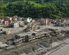
The waters did not simply rise; they shattered the topography. When a wall of glacial melt, torrential rain, and liquefied debris tore down the steep gorges connecting the Tibetan plateau to the river valleys of Nepal, it left more than 1,300 dead in its wake. Recent scientific attribution models confirm what residents living beneath the shadow of the world's highest peaks already knew in their bones. This disaster bears the distinct, undeniable fingerprints of a rapidly warming planet.
Yet, pointing the finger at global carbon counts masks a far more urgent, localized machinery of failure. It allows governments, international agencies, and regional planners to treat institutional negligence as an act of God. The catastrophe was years in the making, driven by a lethal combination of unmonitored glacial lake expansion, severe transboundary data blackouts, and infrastructure built for a climate that vanished decades ago. While global climate negotiations drag on in air-conditioned conference rooms thousands of miles away, the communities living along these high-altitude arteries are paying the price in blood and displaced lives, abandoned by systems that refuse to adapt to empirical reality. Learn more on a similar subject: this related article.
The Hydraulic Math of the Third Pole
To understand why the gorges flooded with such apocalyptic force, one must examine the peculiar physics of the Hindu Kush Himalaya region, often designated the Third Pole. As global temperatures creep upward, the glaciers feeding the transboundary river basins are retreating at unprecedented speeds. This retreat does not merely empty the ice fields; it creates high-altitude liquid storage containers known as glacial lakes. These lakes are held back by natural moraine dams—loose piles of rock, boulders, and sediment dumped by ancient glaciers over centuries of advance and retreat.
Unlike engineered concrete dams equipped with spillways, drainage tunnels, and seismic monitoring equipment, moraine dams are inherently unstable geological formations. They are ticking clocks. When an extreme weather event dumps unprecedented volumes of rain onto snowpacks that should have remained frozen, or when a massive ice avalanche plunges into an overfilled lake, the resulting displacement wave breaches the moraine wall. The natural dam collapses catastrophically within minutes. A glacial lake outburst flood is unleashed with devastating momentum. Further reporting by NPR explores similar views on this issue.
The recent disaster in the Nepal-Tibet borderlands combined two distinct hydrological phenomena: a sudden glacial lake outburst event amplified by an exceptionally heavy, erratic monsoon rainfall pulse. Climate models project that for every single degree Celsius the atmosphere warms, its capacity to hold moisture increases by roughly seven percent. That thermodynamic reality translates directly into heavier, more concentrated cloudbursts over high-altitude mountain terrain. The mountains can no longer absorb the blow. The soil is saturated, the slopes are destabilized, and when the lakes let go, the valleys turn into aqueous battering rams that scour bedrock clean of topsoil, vegetation, and human habitation alike.
The Transboundary Information Blackout
Water does not respect geopolitical borders, but hydrometeorological data often stops dead at national checkpoints. The geographical reality of the Himalayas means that the headwaters and critical meteorological triggers originate in Chinese-administered Tibet, while the catastrophic downstream impacts are absorbed by Nepal and, further down the watershed, India.
This geographic arrangement creates a dangerous information asymmetry. Early warning systems depend entirely on upstream telemetry. If meteorologists and disaster management authorities in Kathmandu or local riverbank villages do not know what is happening in the high-altitude Tibetan catchments, they are effectively flying blind. While bilateral agreements and scientific exchanges occasionally occur, real-time data sharing during extreme weather events remains dangerously fragmented.
Information is delayed by bureaucratic friction, diplomatic sensitivities, and a lack of automated, cross-border sensor networks. When thousands of tons of water and mud are hurtling down a narrow gorge at highway speeds, a delay of twenty minutes in relaying satellite data or stream-gauge readings represents the difference between mass evacuation and mass grave. The border is not just a political line on a map; it is an administrative barrier that impedes survival. Upstream monitoring stations exist, but the data collected within Tibetan territory rarely flows downstream with the speed required to save lives in lower riparian communities. Until regional governments treat hydrological data as a humanitarian necessity rather than a matter of state security, these preventable tolls will continue to mount. Diplomatic channels must be decoupled from disaster mitigation, allowing automated telemetry to cross borders as freely as the rivers themselves.
Engineering for a Ghost Climate
Civil infrastructure across the Himalayan corridor suffers from a fundamental design flaw: it is engineered backward. Roads, bridges, hydropower stations, and settlements are designed using historical hydrological data from the mid-to-late twentieth century. Engineers calculate peak flood discharges based on century-old rainfall records and historical river flows, assuming that climate systems operate within a stationary, predictable band of historical variance.
That assumption is dead. The climate is non-stationary. A hundred-year flood event now occurs every decade, or every few years.
Consider the proliferation of run-of-the-river hydropower projects carved into these fragile river valleys. Eager to tap clean energy sources to fuel national development grids, planners have peppered the steep gorges with concrete intakes, tunnels, and penstocks. These structures are often battered by high-velocity sediment loads and unexpected surges. When a massive debris flow or glacial lake outburst hits these installations, the concrete structures act as bottlenecks, trapping debris, creating temporary artificial dams, and then releasing even more destructive secondary waves when those temporary barriers fail.
Furthermore, road construction in the rugged borderlands has accelerated rapidly. Mountain roads blasted into fragile hillsides generate massive quantities of loose rock and soil, known locally as spoil. During intense monsoon rains, this loose earth is washed into the river systems, significantly increasing the sediment load and turning ordinary rivers into viscous slurries of mud and boulders that possess far greater destructive energy than clean water alone. Human intervention has effectively supercharged the natural erosive power of the terrain, turning development projects into hazard multipliers.
The Economics of Downstream Abandonment
Downstream communities bear the brunt of these compounding failures, yet they are systematically excluded from resource allocation and disaster preparedness planning. In remote valleys, warning systems often consist of nothing more than community members watching the riverbank or rudimentary sirens that fail during power outages caused by storms.
Building comprehensive, community-managed early warning systems requires sustained financial investment and long-term institutional support. However, central governments frequently prioritize high-visibility, capital-intensive urban infrastructure over rural disaster mitigation. When a flood wipes out an isolated village, the economic loss is locally catastrophic but barely registers on national gross domestic product indices, rendering the victims statistically invisible until the death toll hits numbers that can no longer be ignored.
Insurance markets offer little recourse. Parametric insurance and climate risk financing mechanisms are virtually non-existent for subsistence farmers and small-scale traders living along the Himalayan river corridors. When their homes, livestock, and arable land are washed away, they are pushed into generational debt or forced to migrate to urban slums, adding to the silent refugee crisis driven by environmental degradation. Without targeted financial instruments and decentralized risk management, the poorest residents of these mountain valleys remain perpetual shock absorbers for regional climate volatility.
Moving Beyond Crisis Rhetoric
The scientific consensus is absolute. The floods in Nepal and Tibet were turbocharged by global warming. But stopping the analysis at climate change is an intellectual cop-out that protects bureaucratic inertia. Solving this crisis requires abandoning the reactive cycle of disaster response.
Governments must establish mandatory real-time transboundary data-sharing protocols across the Himalayan watersheds, decoupling hydrometeorological observation from geopolitical rivalries. Engineering standards must be completely overhauled to account for non-stationary extreme weather projections, ensuring that bridges and hydropower facilities are not obsolete before construction is even completed. Early warning networks must be funded as primary life-safety infrastructure rather than secondary aid projects, placing control directly in the hands of vulnerable riverbank communities.
Until structural vulnerabilities, institutional silos, and data blackouts are addressed with the same urgency as carbon reduction targets, the valleys beneath the roof of the world will remain exposed to disasters that are entirely within human power to mitigate. The water is already rising, and the margin for bureaucratic delay has officially expired.