Most people stare at airplane contrails and just see condensation. Aviators look at the same stretch of empty air and see an invisible blank canvas. Thanks to modern flight-tracking technology, a growing subculture of pilots is turning routine cross-country navigation into high-precision GPS drawing.
When an Ohio-based pilot spent six grueling hours in the cockpit tracing out a massive map and text tribute to celebrate the nation's milestone anniversary, it wasn't just a quirky stunt. It was a masterclass in flight planning. Drawing complex geometric shapes thousands of feet in the air requires treating your aircraft like a giant, flying mouse cursor.
The Mechanics Behind GPS Flight Art
You can't just draw freehand loops in an airplane and hope for the best. Aviation art relies entirely on ADS-B transponders and public tracking platforms like Flightradar24. Every second, your plane broadcasts its precise latitude and longitude. Software connects those data points with a continuous line.
If your heading drifts by even two degrees due to a crosswind, your straight line becomes a jagged mistake. Pilots attempting these visual feats must account for wind aloft, fuel burn weights, and restricted military airspace. A single miscalculated vector means starting a curved line over again.
Pilots use specialized flight planning software long before they ever touch the ignition switch. They plot waypoints over small towns, intersections, and VOR stations. They fly the route with the mechanical precision of a surgeon.
Why Pilots Actually Waste Fuel to Draw Pictures
Critics often wonder why anyone burns hundreds of gallons of expensive aviation fuel just to draw a cartoon plane, a holiday character like the Grinch, or an outline of the United States. The answer usually comes down to two practical reasons.
First, student and commercial pilots need to log specific hours to maintain currency or upgrade their certifications. Flying in straight lines back and forth across a boring Midwestern grid gets old fast. Turning a mandatory cross-country training flight into an intricate puzzle keeps navigation sharp.
Second, it turns aviation into performance art. The general public rarely understands the tedious math behind flight planning. When a pilot traces an outline that goes viral online, millions of people suddenly open up flight trackers to watch a tiny icon trace an ear or a wingtip in real time.
The Un
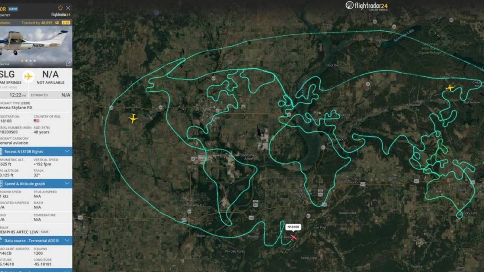
How One Pilot Drew a World Map and His Airplane in the Sky
travel
Most pilots file a flight plan to get from point A to point B as efficiently as possible. They save fuel. They satisfy air traffic controllers. They stick to the corridor.
Then you have pilots who treat the open air like a blank canvas.
GPS tracking has turned cockpit instrumentation into a creative medium. If you have a transponder broadcasting your coordinates to the world, anyone with an internet connection can watch your exact path. Aviators figured this out years ago. They started tracing letters, shapes, and massive drawings across the sky using nothing more than a yoke, a throttle, and precise timing.
Some flight art looks like a sloppy scribble. But every once in a while, a pilot pulls off something that stops people in their tracks.
The Flight That Broke the GPS Tracking Mold
Take the story of a US aviator who decided to sketch an entire world map and an outline of his own aircraft using the continental United States and local airspace as his sketchbook. It sounds impossible. You cannot just pause an airplane in mid-air to switch brushes. Every line requires moving at hundreds of miles per hour, factoring in crosswinds, fuel consumption, and restricted military zones.
This wasn't done on a whim. Sky art requires hours of pre-flight planning.
When you look at flight tracking data from specialized feats like this, you realize the margin for error is razor-thin. If you miss a turn by a quarter-mile because of unexpected turbulence, your continent looks deformed. Your airplane shape turns into a blob.
Why Pilots Draw in the Sky
People ask why anyone wastes expensive aviation fuel to draw pictures. The answer usually comes down to breaking up the monotony of routine flying, testing navigational precision, or occasionally, making a statement.
Flight tracking apps made civilian aviation transparent. Before flight-tracking platforms like Flightradar24 became household names, a pilot's path was private business. Today, thousands of aviation geeks watch live traffic just to catch unusual patterns. Aviators know this. When they execute a massive sky drawing, they are performing for a digital audience.
It is also an elite test of instrument flying skills. Drawing a detailed outline requires strict adherence to heading and airspeed. You have to fly complex geometric vectors while managing your engine parameters and talking to ground control.
The Logistics Behind Aerial Artwork
You cannot just draw a smiley face at thirty thousand feet without clearance. Air traffic control watches every blip on the radar. If a plane starts flying in erratic loops over a busy sector, controllers want to know why.
Most sky artists plan their routes over sparsely populated areas or designated training zones. They use specialized flight planning software to map out latitude and longitude waypoints before stepping foot near a cockpit.
Here is what goes into a successful sky drawing:
- Waypoint Precision: Every single turn must be calculated down to the second to account for ground speed.
- Fuel Management: Drawings take hours. You need reserve fuel for unexpected holding patterns or reroutes.
- Wind Correction: A thirty-knot crosswind will push your aircraft sideways and ruin the geometry of your drawing. You have to crab into the wind while maintaining the illusion of a straight line.
Moving Past Gimmicks
Sky art gets plenty of viral attention on social media. Photos of flight paths shaped like birds or seasonal greetings pop up around the holidays. But the world map and airplane project stands apart because of its sheer scale.
When an aviator commits to mapping out complex geographic features through flight paths, they are treating the sky as a monument. It reminds us that aviation still has room for whimsy. Flying can feel corporate and sterile. You pack into a commercial jet, stare at the back of a seat, and land three time zones away.
Independent pilots remind us that the sky is still a vast space for human expression.
If you want to try tracking unusual flights yourself, stop relying on mainstream news alerts. Keep an eye on tracking platforms during off-peak hours when training aircraft take to the skies. You might just catch someone sketching their next masterpiece in real time.